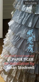
02 Apr Susan Stockwell: Paper Tiger

Paper Tiger:
An installation by Susan Stockwell
23 June – 29 August 2008
Lobby, One Canada Square Canary Wharf, London, E14
With trails and trains, ruffles and drapes, artist Susan Stockwell, who has employed paper in her installations since the 1990s, has this time achieved something different. Using paper in seemingly endless ways – always inventively and often specific to a particular site – she folds, pleats, gathers, stacks, wraps, embroiders, sews, cuts, glues and staples her art.
Putting site specificity aside on this occasion, she has created an installation for One Canada Square that challenges the corporate environment. Instead of paper shredded or filed away, or in neat bundles ready for use as one might expect in the workplace, she has appropriated maps and rice paper to create dresses that a Victorian lady might have worn. In the more extravagant pieces, with frills and flounces of frocks such as those favoured by girls pictured in the exuberant and hedonistic paintings of Jean-Honoré Fragonard (1732-1806), Stockwell reflects on an earlier period. The white abundance of the installation gives pause for thought. These are ghosts of a bygone age, standing mute in their alien environment, tied to the architecture of the Lobby’s southern side.
This is the first time that Stockwell has used rice paper in her work. During a recent studio residency in Taiwan she was introduced to this lustrous paper; its soft surface catches the light like silk, which encouraged her towards these extravagant forms.
These new works are a progression from Stockwell’s dresses made from maps, which are also shown in the exhibition, together with Imperial Quilt (2005). Colonial Dress (2008) is made from maps of the British Empire, while in Highland Dress (2008) she has used pink maps of Scotland. The maps’ contours accentuate those of the human form – a playful notion in works that seem to have been taken from a museum showcase.
The way in which Stockwell uses maps alludes to issues such as territories and colonies, the ownership of land and its constantly shifting boundaries. There are so many implications over and above the physical appearance of the work. Maps can indicate trade and trading routes, the economic landscape, geological variations and rainfall. They are a rich resource, used here to good effect.


